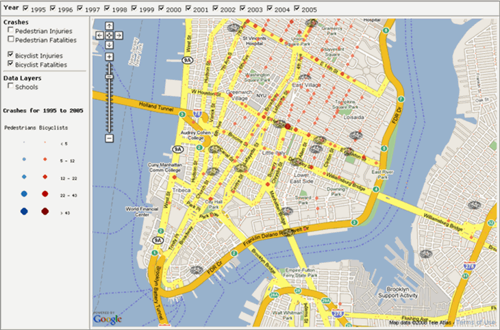
Transportation Alternatives has launched a new and improved version of their Crash Stat Map that now uses Google maps and includes data from 2004 and 2005. The location of accidents and fatalities involving bicycles are mapped city wide making this a useful tool for finding streets and intersections to avoid and/or be extra cautious when using.
10 Most Dangerous Intersection in New York City based on Number of Bicycle Crashes
| Rank | Intersection | Crashes |
| 1 | Bowery & W Houston St | 29 |
| 2 | Broadway & Union sq W | 29 |
| 3 | E 23rd St & Park Ave Southbound | 24 |
| 4 | W 23rd St & Avenue of the Americas | 24 |
| 5 | 5th Ave & W 34th St | 24 |
| 6 | Adams St & Tillary St | 24 |
| 7 | Essex St & Delancey St | 24 |
| 8 | W 96th St & Broadway Southbound | 24 |
| 9 | 1st Ave E & Houston St | 22 |
| 10 | E 125th St & Lexington Ave | 21 |
From CrashStat.org: When Transportation Alternatives launched Crashstat.org in 2004, it immediately became an indispensable resource for advocates, neighborhood groups and healthcare professionals in their fights for safer streets. For the first time, all New Yorkers had a way to see pedestrian and cyclist crashes in every neighborhood, enabling them to back up their first-hand experience of dangerous streets with comprehensive hard data. Crashstat.org is still the go to source for street safety information.
Crashstat 2.0 is an updated and improved version of that ground breaking site. Journalists, planners, politicians and New Yorkers from every walk of life will once again have access to NYC’s most up to date street safety resource.