
RTC recently launched Trail Traveler, a new digital magazine for tablet computers that is chock full of details for planning trips on 10 premier rail-trails […]
RTC recently launched Trail Traveler, a new digital magazine for tablet computers that is chock full of details for planning trips on 10 premier rail-trails […]
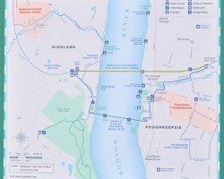
75 miles North of NYC (as the bike rides), cyclists and pedestrians now have their own Hudson River crossing. The Walkway Over the Hudson is […]

Westchester County, New York City’s neighbor to the North, is home to the North County & South County trailways. These Westchester trails are part of […]